Updated severe weather risk Thursday
UPDATE: The National Weather Service has issued a Severe Thunderstorm Watch until 9:00 p.m. for portions of Minnesota including Aitkin, Carlton, Cass, Crow Wing, Itasca, Lake, Pine, and St. Louis counties. Portions of Wisconsin, including Ashland, Barron, Bayfield, Burnett, Douglas, Iron, Price, Sawyer and Washburn counties are also under a Severe Thunderstorm Watch. Strong storms with gusty winds and hail are possible this afternoon and evening.
Track the storms with the Interactive Radar.
[anvplayer video=”5186705″ station=”998130″]
One more hot and humid day lies ahead before a more seasonable stretch of weather arrives for the weekend. Highs today reach mid-80s to low 90s, and Lake Superior won’t be as much help to us this time. Heat indices will approach 100 for east central Minnesota into northwest Wisconsin. A southwest wind spreads the warmth down the hill in the Twin Ports. Dew points will climb to tropical heights in low to mid-70s, fueling potentially severe thunderstorms.
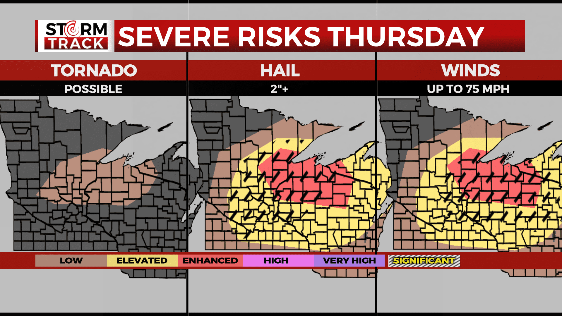
An early round of thunderstorms exits east this morning with only spotty showers lingering. We first look near and north of the Iron Range this afternoon for storms that may produce large hail and damaging winds. Storms then move southward across the Northland through the afternoon and evening. East central Minnesota and northwest Wisconsin holds the greatest chance for 2″ hail, 75 mph winds, and a stray tornado. Be weather aware and be prepared to move outdoor plans indoors.
The severe threat marches southeast through the evening and exits the Northland before midnight. Some showers and non-severe thunderstorms may linger overnight into early Friday morning. Friday keeps a low chance of thunderstorms in the afternoon and evening. It will otherwise feature highs in mid-70s to low 80s with cooler conditions near Lake Superior.
Today: Hot and humid under partly sunny skies. Showers and thunderstorms possible before 10 am, then potentially severe storms possible after 3 pm. High 88. SW wind 5-10 mph. Chance of rain: 60%
Severe Risks Thursday (Updated 2:15 pm)
Tonight: Scattered thunderstorms early, then becoming partly cloudy. Low 60. NE wind 5-10 mph. Chance of rain: 40%
Tomorrow: Partly cloudy, breezy, and cooler with a slight chance for showers and thunderstorms. High 75. E wind 10-15 mph.
Tomorrow night: Partly cloudy. Low 55. NE wind 5-10 mph.
Saturday: Mostly sunny. High 75. N wind 5-10 mph.
Sunday: Mostly sunny. High 77. NW wind 5-10 mph.
Monday: Mostly sunny. High 79. S wind 5-10 mph.
Tuesday: Partly cloudy. High 79. SE wind 5-10 mph.
Wednesday: Partly sunny with isolated thunderstorms. High 81. W wind 5-10 mph. Chance of rain: 30%.