2022 in Review: Weather Edition
As we look forward to 2023, let’s take a look at this past cold, wet year from a weather and climate perspective.
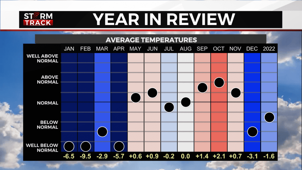
We’re ending 2022 with above-average temperatures, a far cry from how this year began. The first few months were much colder than normal.
January 1, 2022 had a morning low of -23°. This was the coldest temperature for not only the month but also the year. We stayed below average for most of January and had only one day above freezing.
February was the most below normal temperature-wise for the entire year. It was also quite snowy, with 18.8” in Duluth. The cold conditions and a growing snowpack would prove to be an issue later in the year.
We stayed cooler than normal for the remainder of the winter and much of spring. In fact, in early May, many were worried about ice on lakes ahead of the Minnesota and Wisconsin fishing openers.
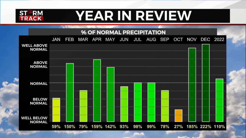
While inland lakes were still icy by the end of the month, there was significant melting in the middle of April. In Duluth, there was 4.02” of rain, which is 59% above average. This was the wettest April on record for the Rainy Lake Basin, causing historic flooding that would take months to recover from.
The summer months were close to normal for both temperatures and precipitation. August actually had a temperature departure from normal of zero and just 0.04 inches of rain below normal.
Fall began a little on the dry side, with October having the lowest percentage of precipitation compared to normal. November, however, made up for this with 85 percent more precipitation than normal. The month of November also featured above-average temperatures and plenty of gales on Lake Superior.
Wet and windy conditions continued into December as we had our only blizzard of the year. What started as a wintry mix late on December 13th eventually became snow. Two days of wet, heavy snow throughout the Northland. Blizzard conditions were found at the airport twice during what became the eighth largest snowstorm on record in Duluth.
This storm, nicknamed the “Blue Blizzard”, would help this become the snowiest December on record in Duluth, with 44.9” of snow.
Mother nature wasn’t done with us yet- we stayed below zero December 21st and 22nd and had wind chills in the -30s for most of the area. Strong winds also caused many to lose power on Christmas Eve, including the entirety of Cook County.
Overall, 2022 ended up being 1.6 degrees cooler than normal with 2.88 inches of precipitation above normal.
This was also the wettest year on record for International Falls with 35.52 inches of total precipitation.