Sabrina Ullman: South Shore snow starts this afternoon
Old Man Winter is here and will be sticking around for a bit. A large low-pressure system to our south will bring a return of snow chances starting at around 11 am.
For areas north of the Twin Ports, conditions will be clear by Saturday morning, and accumulations will stay under two inches. Areas stretching from the head of the lake through Carlton and Pine Counties will be more in the 2-4 inch range.
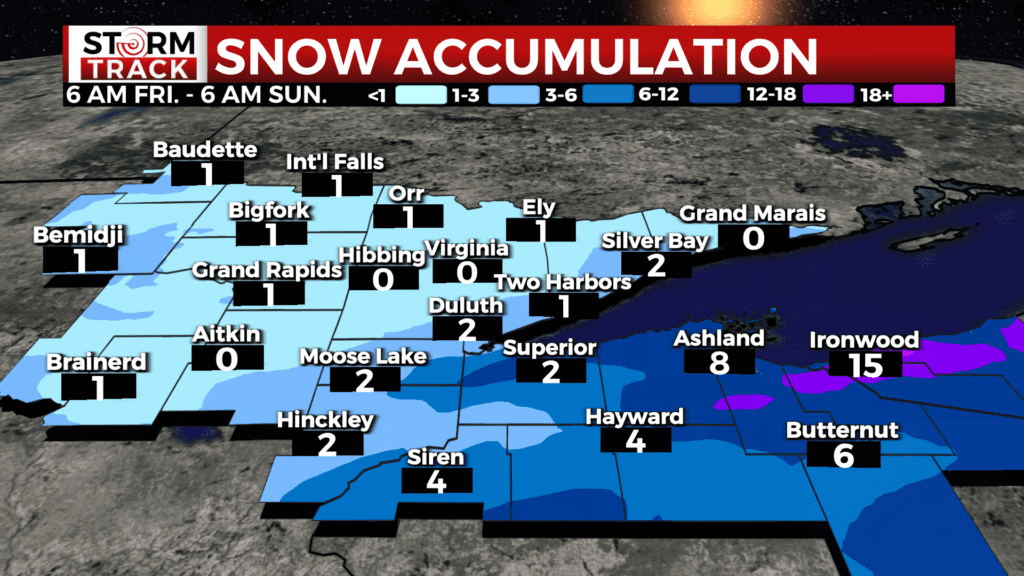
Thursday’s snow brought accumulations of over a foot for portions of the North Shore. Now, the focus turns to the South Shore as winds shift direction. The lake-effect snow machine will bring accumulations of over a foot for areas stretching from Mellen to the U.P. Other areas in northern Wisconsin will have 4-8 inches of snow.
In addition to bringing lake-effect snow to the South Shore, the strong northerly winds will also result in dangerous wind chills from tonight through the weekend. Afternoon highs will be in the teens to low 20s today but feel like the single digits.
This weekend will be frigid with temperatures close to zero at most. Winds will continue to be 10-20 mph from the north, putting wind chill values in the -20s and even into the -30s for some areas by Sunday.
Today
Snow, mainly after noon. High near 16. Blustery, with a north wind 5 to 10 mph becoming northeast 15 to 20 mph in the afternoon. Winds could gust as high as 35 mph. Chance of precipitation is 90%. New snow accumulation of 1 to 2 inches possible.
Tonight
Snow. Patchy blowing snow before 2am. Low around-1. Blustery, with a north wind 15 to 20 mph, with gusts as high as 35 mph. Chance of precipitation is 90%. New snow accumulation of 1 to 3 inches possible.
Saturday
Snow likely, mainly before 8am. Patchy blowing snow before noon, then patchy blowing snow after 5pm. Cloudy, with a high near 8. Blustery, with a north wind 15 to 20 mph, with gusts as high as 35 mph. Chance of precipitation is 60%. New snow accumulation of 1 to 2 inches possible.
Sunday
Patchy blowing snow before 9am, then patchy blowing snow after 4pm. Mostly cloudy and cold, with a high near 1. Blustery, with a northwest wind around 20 mph, with gusts as high as 30 mph.
M.L.King Day
Patchy blowing snow before 7am. Mostly cloudy and cold, with a high near 0. Breezy, with a west wind 15 to 20 mph, with gusts as high as 30 mph.
Tuesday
Mostly cloudy and cold, with a high near 4. Breezy, with a west wind around 15 mph, with gusts as high as 25 mph.
Wednesday
A slight chance of snow. Mostly cloudy, with a high near 9. Breezy, with a west wind 10 to 15 mph, with gusts as high as 20 mph.
Thursday
A slight chance of snow. Mostly cloudy, with a high near 7. Blustery, with a northwest wind around 15 mph, with gusts as high as 25 mph.