Sabrina Ullman: Multiple rounds of rain this week
After a pleasant Sunday, we are in for a cool, rainy week ahead. Tonight will have overnight lows near 50 degrees and scattered showers moving from west to east.
Rain will continue into Monday, clearing out by the evening. This first round of rain will have around a quarter of an inch throughout the Northland.
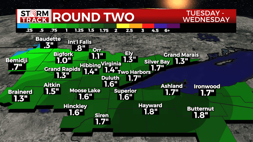
We will have a brief break Monday night into Tuesday morning before another system moves in from the west on Tuesday afternoon. This system will be much more impactful with rain lasting through Wednesday. Widespread accumulations of over an inch are likely, and higher amounts are possible in some areas.
In addition to potential for localized flooding, Tuesday’s storms will bring a chance for severe weather. Areas from North Branch to Hayward and southeast could see scattered severe thunderstorms. From there to the Twin Ports, we have a risk of isolated severe thunderstorms. These severe thunderstorms could have wind gusts up to 60 mph, hail up to an inch in diameter, and potentially even a tornado. Extra caution is advised Tuesday afternoon to evening with the aforementioned risks.
Temperatures this week will be cooler, with highs in the 50s and 60s all week.
Tonight
A chance of rain before 3am, then showers likely between 3am and 4am, then showers likely and possibly a thunderstorm after 4am. Increasing clouds, with a low around 50. Southeast wind around 5 mph. Chance of precipitation is 70%. New rainfall amounts between a tenth and quarter of an inch, except higher amounts possible in thunderstorms.
Monday
Showers and thunderstorms likely before 10am, then a chance of showers between 10am and 1pm. Patchy fog before 3pm. Otherwise, cloudy, with a high near 62. East wind around 10 mph becoming northwest in the afternoon. Chance of precipitation is 60%. New precipitation amounts of less than a tenth of an inch, except higher amounts possible in thunderstorms.
Tuesday
A chance of rain, then rain likely and possibly a thunderstorm after 1pm. Mostly cloudy, with a high near 58. Breezy, with an east wind 10 to 20 mph, with gusts as high as 30 mph. Chance of precipitation is 70%. New rainfall amounts between three quarters and one inch possible.
Wednesday
Showers likely and possibly a thunderstorm. Mostly cloudy, with a high near 58. Breezy, with a north wind 15 to 20 mph becoming west in the afternoon. Winds could gust as high as 30 mph.
Thursday
Mostly sunny, with a high near 60. Breezy, with a west wind around 15 mph, with gusts as high as 20 mph.
Friday
A chance of showers. Partly sunny, with a high near 58. Breezy, with an east wind 10 to 15 mph, with gusts as high as 20 mph.
Saturday
A chance of showers. Partly sunny, with a high near 65. Breezy, with a northeast wind 10 to 15 mph becoming west in the afternoon. Winds could gust as high as 20 mph.
Sunday
A slight chance of showers. Mostly sunny, with a high near 64. North wind 5 to 10 mph, with gusts as high as 15 mph.