Brandon Weatherz: Tracking heavy snow north and a cool down
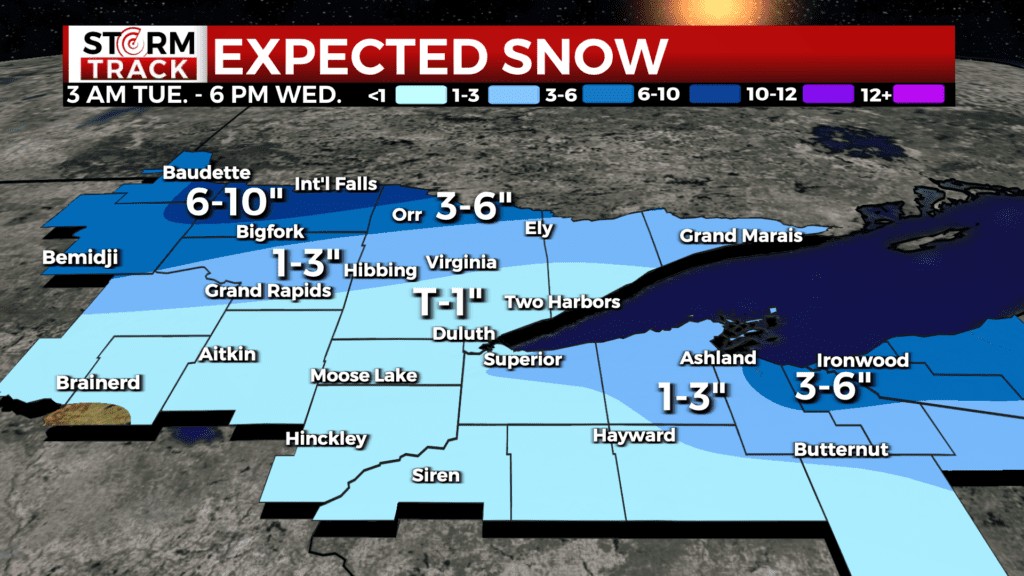
A strong cold front passing the region today will bring a dramatic fall in temperatures and heavy snow that will impact travel in parts of north central Minnesota. The heaviest snow will be near International Falls with 6-10″ possible, leading to a Winter Storm Warning for Koochiching County until 6 pm. Accumulation will quickly drop off moving south with 3-6″ for North Itasca and North St. Louis County where a Winter Weather Advisory is also in effect until 6 pm. Expect travel to quickly deteriorate this morning and remain difficult through the afternoon with things quieting down here in the evening.
In addition to heavy snow, strong north winds with gusts that may exceed 40 mph could cause times of whiteout conditions. Snow will fill out more of the Northland from west to east through the afternoon and evening, then focus along the South Shore tonight. A Winter Weather Advisory is in effect for Iron County from 6 pm today to 6 am Wednesday. Expect 3-6″ for here, eastern Ashland County, and much of Gogebic County.
Apart from the areas in weather headlines, much of the rest of the region will see between a trace and a couple of inches with under an inch still expected for the Twin Ports. The Iron Range and Grand Rapids are on the southern edge of potential for 1-3″.
The other big piece of this system will be the influence on our temperatures. As cold air takes over from the northwest, highs range from 20s by International Falls to 50s near Hayward. The Twin Ports will top off in the morning in upper 30s, then the temp falls steadily through the day.
Wednesday morning starts cold with temps ranging from single digits in northern Wisconsin to minus teens in north central Minnesota, and wind chills between -15 and -30 are possible. Highs then stay in single digits to near 20 on Wednesday with sunny skies. We’re on track for a welcomed warm up through the end of the week with 50s making a comeback on Friday.
Today: Cloudy and windy with a chance for snow after 3 pm. Morning high of 37 with temp falling. N wind 15-25 mph gusting to 40 mph. Chance of snow: 30%
Tonight: Mostly cloudy and windy with a slight chance for snow. Low 2. NNW wind 15-25 mph.
Tomorrow: Sunny, breezy, and cold. High 17. WNW wind 10-20 mph.
Tomorrow night: Mostly clear. Low 5. W wind becoming S 5-15 mph.
Thursday: Partly cloudy. High 35. SE wind 5-15 mph.
Friday: Sunny, warmer, and breezy. High 52. SSW wind 10-20 mph.
Saturday: Mostly cloudy and breezy. High 45. E wind 10-20 mph.
Sunday: Cloudy and breezy with a chance for rain. High 47. E wind 15-20 mph. Chance of rain 40%.
Monday: Cloudy and breezy with a chance for rain and snow. High 43. WSW wind 10-20 mph. Chance of precip: 40%