Sabrina Ullman: Snow tonight, tomorrow, and more
[anvplayer video=”5170296″ station=”998130″]
Our Thursday begins with clear skies, but we will soon see clouds increase followed by a return of precipitation chances. Afternoon highs will be in the upper thirties.
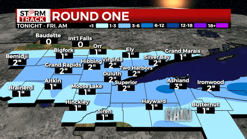
Snow will enter the Northland from the south this afternoon, reaching the Twin Ports by 7 pm. The Iron Range and areas south are all under a Winter Weather Advisory from 7 pm tonight until tomorrow morning. Expected accumulations for this round will be mostly 1-3 inches, with less close to the international border as well as south of Hayward.
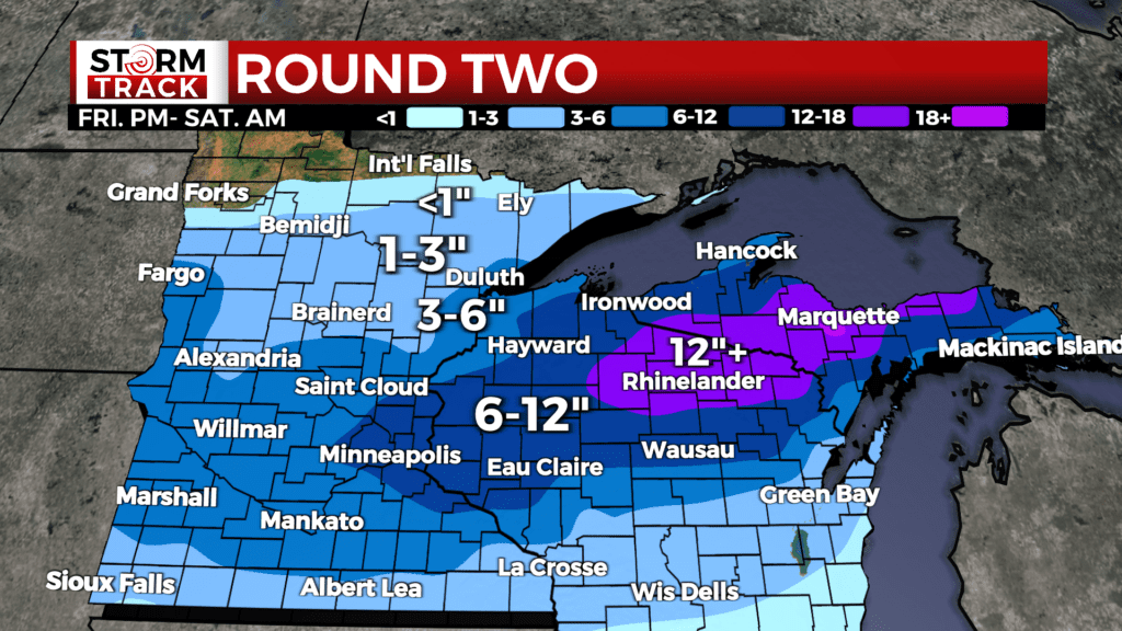
We will have a slight break midday Friday before round two moves in Friday afternoon. This round of snow will mostly only impact areas south of Highway-2, but we will see more accumulation for northern Wisconsin than in tonight’s round.
Accumulations Friday night to Saturday will be under three inches west of the Twin Ports. Areas close to the head of the lake will be in the 3-6” range, while the rest of northern Wisconsin will likely have over half a foot. A Winter Storm Watch has been issued for portions of the Northland, in effect from 7 pm Friday night until 7 am Saturday morning.
Mixed precipitation is likely Sunday night. There is potential for a winter storm Tuesday-Wednesday that the Storm Track Weather Team is monitoring closely. Stay tuned for updates as that gets closer.
Today
Increasing clouds, with a high near 32. West wind 5 to 10 mph becoming south in the afternoon.
Tonight
Snow will enter the Northland from the south this afternoon, reaching the Twin Ports by 7 pm. The Iron Range and areas south are all under a Winter Weather Advisory from 7 pm tonight until tomorrow morning.
Snow before midnight, then snow and freezing rain. Low around 25. Breezy, with an east wind 5 to 15 mph, with gusts as high as 30 mph. Chance of precipitation is 90%. New ice accumulation of around a 0.1 of an inch possible. New snow accumulation of 1 to 3 inches possible.
Friday
A chance of snow and freezing rain before 10am, then a chance of rain, snow, and freezing rain between 10am and 1pm, then snow likely after 1pm. Cloudy, with a high near 35. Breezy, with a northeast wind around 20 mph, with gusts as high as 35 mph. Chance of precipitation is 60%. New ice accumulation of less than a 0.1 of an inch possible. New snow accumulation of around an inch possible.
Saturday
Sunny, with a high near 35. Breezy, with a north wind 15 to 20 mph becoming east 5 to 10 mph in the afternoon. Winds could gust as high as 30 mph.
Sunday
A chance of snow before 1pm, then a chance of rain and snow. Partly sunny, with a high near 45. Breezy, with a south wind around 15 mph, with gusts as high as 25 mph.
Monday
Partly sunny, with a high near 40. Breezy, with a west wind 10 to 15 mph, with gusts as high as 20 mph.
Tuesday
Snow likely, possibly mixed with rain. Mostly cloudy, with a high near 33. Breezy, with an east wind 15 to 20 mph, with gusts as high as 35 mph.
Wednesday
A chance of snow. Mostly cloudy, with a high near 37. Windy, with a northeast wind around 25 mph, with gusts as high as 40 mph.