Sabrina Ullman: Heaviest snowfall tonight as system slowly moves east
[anvplayer video=”5172774″ station=”998130″]
Areas west of the Twin Ports are mostly done with this round of snow, but the rest of the Northland will have heavy snowfall overnight into Monday morning. A slick morning commute is likely Monday.
Monday’s snow will primarily be over the Arrowhead region and the South Shore as this system slowly moves east. By 10 pm Monday, conditions will be clear west of Ashland County. By 5 am Tuesday, the rest of the area will have clear skies.
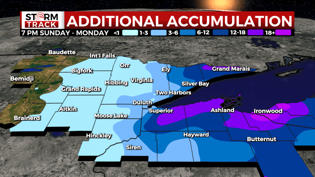
A Blizzard Warning is in effect for Douglas, Bayfield, Ashland, Iron, and Gogebic Counties because of the additional accumulations combined with winds up to 45 mph. There is also a Blizzard Warning for the North Shore of Cook County because of the strong northwesterly winds that could cause blowing snow and reduced visibility tonight.
A Winter Storm Warning is in effect for Washburn, Sawyer, Price, Lake, and northern Cook Counties. All Blizzard and Winter Storm Warnings expire at 7 pm Monday.
A Winter Weather Advisory is in effect for St. Louis, Carlton, Pine, Burnett, and southern Itasca Counties until 1 am tonight.
Ongoing flooding remains a concern- with afternoon highs in the low forties this week, this new snow is expected to melt quickly. There is also a chance of rain Wednesday, becoming snow Wednesday night. Snow chances continue from then through the weekend.
Areas west of the Twin Ports are mostly done with this round of snow, but the rest of the Northland will have heavy snowfall overnight into Monday morning. A slick morning commute is likely Monday.
Related: Road closures due to flooding
The Minnesota and Wisconsin portions of the Northland are still under a Flood Advisory, while the U.P. is under a Flood Watch. There are also several Flood Warnings in effect that can be found on the WDIO website.
Tonight
Snow, mainly before 9pm. Patchy blowing snow. Low around 24. Windy, with a north wind around 25 mph, with gusts as high as 45 mph. Chance of precipitation is 80%. New snow accumulation of 1 to 2 inches possible.
Monday
A 50 percent chance of snow, mainly before 5pm. Patchy blowing snow before 2pm. Mostly cloudy, with a high near 40. Windy, with a north wind 20 to 25 mph, with gusts as high as 40 mph. New snow accumulation of less than a half inch possible.
Tuesday
Sunny, with a high near 46. Breezy, with a north wind 5 to 15 mph becoming east in the afternoon. Winds could gust as high as 20 mph.
Wednesday
A chance of rain, snow, and freezing rain before 1pm, then rain and snow likely. Mostly cloudy, with a high near 36. Windy, with an east wind 20 to 25 mph, with gusts as high as 40 mph.
Thursday
Rain and snow likely, mainly after 1pm. Patchy blowing snow between 9am and noon. Mostly cloudy, with a high near 39. Windy, with an east wind 20 to 25 mph, with gusts as high as 40 mph.
Friday
Snow likely. Patchy blowing snow. Mostly cloudy, with a high near 37. Breezy, with a north wind 15 to 20 mph, with gusts as high as 30 mph.
Saturday
A chance of snow. Partly sunny, with a high near 38. Breezy, with a north wind around 15 mph, with gusts as high as 25 mph.
Sunday
A slight chance of snow. Partly sunny, with a high near 40. Breezy, with a northwest wind 10 to 15 mph, with gusts as high as 25 mph.