Sabrina Ullman: Record heat continues Monday
[anvplayer video=”5190973″ station=”998130″]
Tonight will be partly cloudy with overnight lows in the 60s to low 70s. Hot, dry weather will continue for Labor Day.
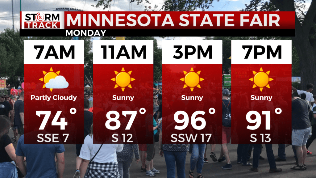
If you are heading to the Minnesota State Fair Monday, you can expect a pleasant morning with it being 74 degrees when the gates open. Temperatures will climb to the upper 80s by midday and then the upper 90s in the afternoon. By the end of the great Minnesota get-together, it will be a toasty 91 degrees.
In the Northland, we set a daily record high Sunday in Duluth, Hibbing, and Brainerd. Duluth and Hibbing even set a monthly record high. We could see more records broken Monday.
Monday will be mostly in the 90s. A southeast wind will keep temperatures a little cooler towards the head of the lake and along the North Shore. Unfortunately, this wind will also mean an increased risk for rip current. Extra caution is advised for those cooling off in Lake Superior.
Another warm day is in store for Tuesday before afternoon highs drop back to the 70s Wednesday. Rain is likely Tuesday afternoon into Wednesday.
Labor Day
Tonight will be partly cloudy with overnight lows in the 60s to low 70s. Hot, dry weather will continue for Labor Day.
Sunny and hot, with a high near 90. Breezy, with an east wind 10 to 15 mph becoming south in the afternoon. Winds could gust as high as 20 mph.
Tuesday
A 30 percent chance of showers and thunderstorms after 1pm. Mostly sunny and hot, with a high near 86. Breezy, with a south wind 15 to 20 mph, with gusts as high as 30 mph.
Wednesday
A chance of showers. Mostly cloudy, with a high near 70. Breezy, with a northwest wind around 15 mph, with gusts as high as 20 mph.
Thursday
Partly sunny, with a high near 65. East wind around 10 mph, with gusts as high as 15 mph.
Friday
Mostly sunny, with a high near 72. East wind 5 to 10 mph becoming west in the afternoon. Winds could gust as high as 15 mph.
Saturday
Sunny, with a high near 70. Breezy, with a northwest wind 10 to 15 mph, with gusts as high as 20 mph.