Justin Liles: WINTER STORM UPDATE: Three major threats!
There are a range of weather concerns coming to the region starting Tuesday. Here is a list of our biggest threats we may see. Freezing rain, heavy snowfall and gusty winds could lead to several problems over the next couple of day. Terrible travel along with power outages are possible.
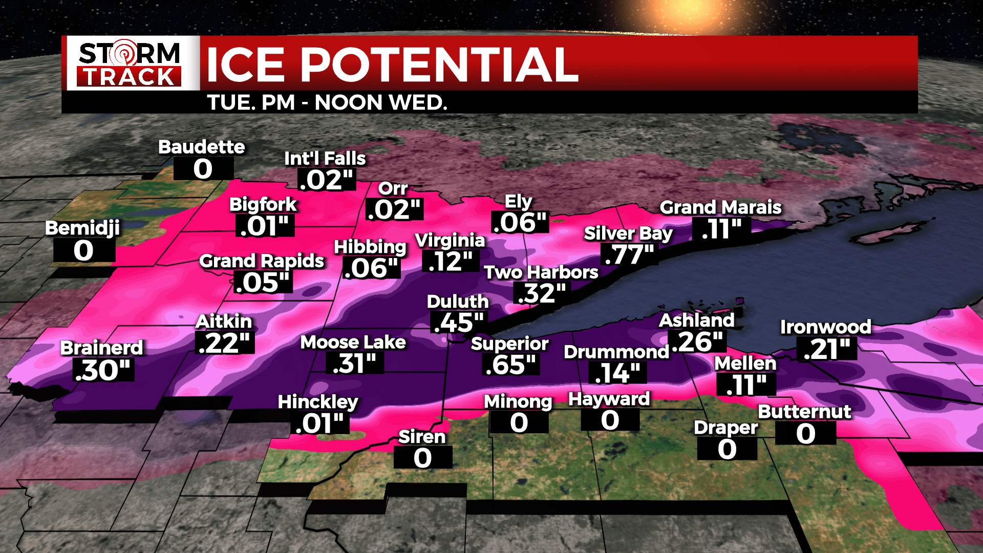
1.) Freezing rain- Best chance for ice accumulation 7PM Tuesday-7AM Wednesday, light freezing rain within wintry mix Tue afternoon and Wed morning. Power outages and ice on roads are biggest concern.
2.) Snow fall: Another wet-heavy snow. Highest confidence for 8”+ over Koochiching, northern Itasca, Northern Cass, & northern St. Louis Counties. Enhanced snowfall amounts along the North Shore of 6-8”+. Along the Iron Range and south to the Twin Ports, 6”+ possible, but higher uncertainty due to wintry mix, freezing rain.
3.) Gusty Winds: Near-blizzard to blizzard conditions possible Tuesday PM – Wednesday AM where snow is falling. Strongest near Lake Superior, where gusts of 45-60 mph are possible. Waves of 10-20 feet on Lake Superior.
Things looks to improve by the holiday weekend. We are looking by the end of the week we should see more sunshine and warmer temperatures. Many areas of the northland may climb into the 50s Saturday and Sunday.
TONIGHT
Cloudy, with a low around 24. Breezy, with an east wind 10 to 20 mph, with gusts as high as 30 mph.
TUESDAY
Snow before 5pm, then snow, possibly mixed with sleet. The snow could be heavy at times. Widespread blowing snow after 10am. High near 31. Very windy, with an east wind 25 to 30 mph increasing to 30 to 35 mph in the afternoon. Winds could gust as high as 50 mph.
TUESDAY NIGHT
Freezing rain, possibly mixed with snow showers and sleet. Some thunder is also possible. Low around 24. Very windy, with an east wind 35 to 40 mph, with gusts as high as 55 mph.
WEDNESDAY
Snow and sleet before 10am, then snow, possibly mixed with rain between 10am and 1pm, then snow likely after 1pm. Patchy blowing snow before 11am, then patchy blowing snow after 2pm. High near 37. Windy, with an east wind 25 to 30 mph becoming east 20 to 25 mph in the afternoon. Winds could gust as high as 50 mph.
WEDNESDAY NIGHT
A 50 percent chance of snow. Areas of blowing snow. Mostly cloudy, with a low around 16. Very windy, with a west wind 25 to 35 mph, with gusts as high as 55 mph.
THURSDAY
A chance of snow, mainly before 1pm. Patchy blowing snow. Partly sunny, with a high near 30. Windy, with a west wind 25 to 30 mph, with gusts as high as 45 mph.
FRIDAY
Mostly sunny, with a high near 37. Northwest wind 5 to 10 mph becoming southeast in the morning. Winds could gust as high as 15 mph.