Justin Liles: Snow, high winds, brutal cold, and slick roads takes aim on the Northland this weekend
Another large low will likely slide in the same direction as low earlier this week and again impact Chicago and southern Wisconsin. This will continue our snow around the region, especially the north shore through Friday morning. As much as 4-7” is possible from Lutsen to Grand Portage in the higher terrain.
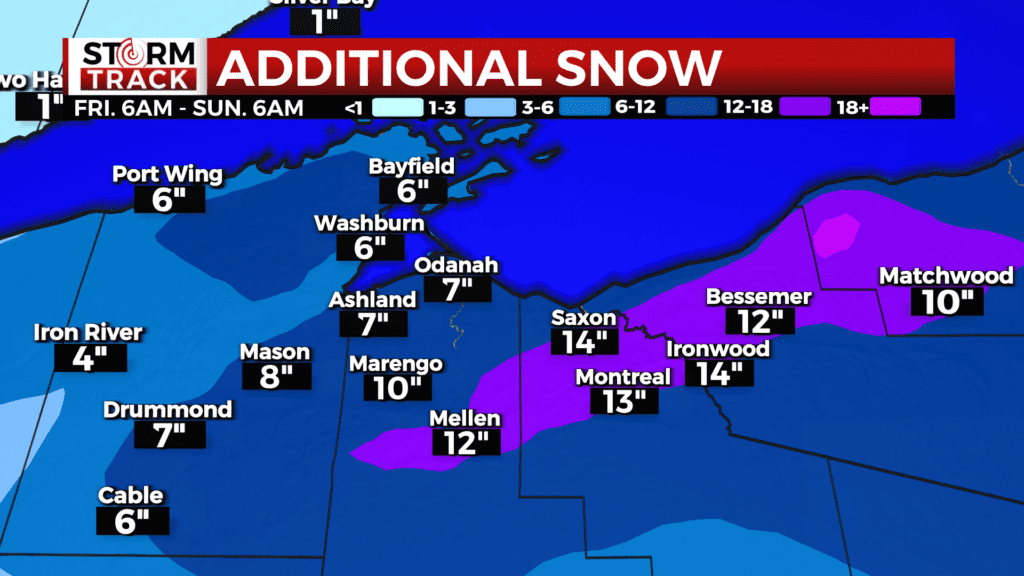
As the low lifts into Ontario, much colder air moves in but so does the start of the lake effect snow machine on the south shore. Significant snowfall is likely starting Friday morning and lasting through Sunday morning along the south shore. Increasing winds will lead to poor travel with blowing and drifting snow too. Bayfield and Ashland counties are under a Blizzard Warning until noon on Saturday.
The snow machine will stay turned on though the end of next week. The colder air coming in will be the coldest air of the year. Daytime highs along the Iron Range and International Border will be below zero. Wind chills Saturday morning will be -15° to -30° and then on Sunday wind chill values will reach -30° to -40°. Colder than average weather looks to stay with us through most of the following week.
TONIGHT
A 20 percent chance of snow after 5am. Mostly cloudy, with a low around 5. West wind 5 to 10 mph becoming north after midnight.
FRIDAY
Snow likely, mainly after noon. Patchy blowing snow after 2pm. Cloudy, with a high near 20. Windy, with a northeast wind 5 to 15 mph increasing to 15 to 25 mph in the afternoon. Winds could gust as high as 40 mph. inches possible.
SATURDAY
A 50 percent chance of snow. Patchy blowing snow. Cloudy, with a high near 6. Windy, with a north wind 20 to 25 mph, with gusts as high as 40 mph.
SUNDAY
Patchy blowing snow. Mostly cloudy and cold, with a high near -3. Blustery, with a northwest wind around 20 mph, with gusts as high as 35 mph.
M.L.KING DAY
Mostly cloudy and cold, with a high near -3. Breezy, with a west wind around 15 mph, with gusts as high as 25 mph.
TUESDAY
Partly sunny and cold, with a high near 3. Breezy, with a west wind around 15 mph, with gusts as high as 25 mph.
WEDNESDAY
A slight chance of snow. Mostly cloudy, with a high near 11. Breezy, with a west wind around 15 mph, with gusts as high as 20 mph.
THURSDAY
A slight chance of snow. Mostly cloudy, with a high near 6. Blustery, with a northwest wind around 15 mph, with gusts as high as 25 mph.