Storm Track Winter Prediction 2023-2024
Each year, the Storm Track Weather Department gets together to research and plan the forecast to help the Northland prepare for the upcoming winter. The team studies past winters locally and global trends to pinpoint what we need to know for the upcoming season.
Brandon Weatherz breaks down the patterns of El Niño; Sabrina Ullman looked at previous winters with a similar trend and Justin Liles investigates the economic impact as well as predicts what each month will bring.
When looking at the big picture weather patterns that will influence our winters, all eyes are on what’s playing out thousands of miles away in the Pacific Ocean.
The El Niño Southern-Oscillation is the relationship between the trade winds and fluctuating ocean temperatures in the central and eastern Pacific. Temperatures here are below average in the cool phase, La Niña, and above average in the warm phase, El Niño.
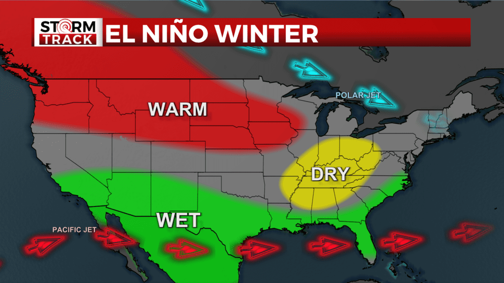
An El Niño winter typically has the pacific jet sending wet weather across the southern U.S. while the polar jet is nudged north, allowing above average temperatures reaching from the Pacific Northwest into parts of the Upper Midwest.
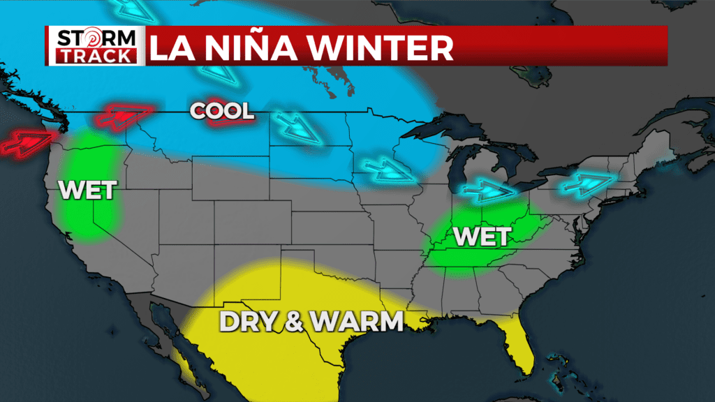
A La Niña winter has more variable jet patterns that tend to keep the Northland cooler. La Niña is what we’ve had for the past three winters.
2020-2021 brought 76.4” of snow to Duluth, which was a good foot below our normal 90.2”. The next year was just a touch above average with 93.4”.
Then there was the season of 2022-2023, the snowiest winter on record in Duluth coming in 140.1”. That’s almost twelve feet!
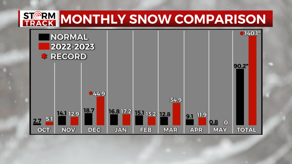
Looking at how each month compared to normal, we only had two significant months. March brought in almost three feet, and December was the snowiest on record with 44.9”. Other months maintained close enough to average for our running total to be 50” above normal.
But, that was last year. we’re done with La Niña. The pacific ocean is currently very warm, positioning us for a strong El Niño.
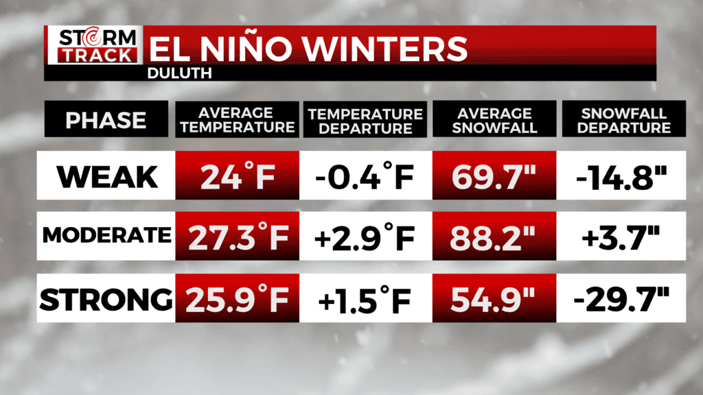
In order to predict this winter, we have to look back at previous El Niño patterns. From October to April, the average temperature and snowfall for Duluth during El Niño depends on the strength of the pattern.
With a weak El Niño, we have a slightly below-average temperature of 24 degrees and an average of 69.7″ of snow. That is almost 15 inches below normal.
A moderate El Niño tends to have an average temperature of around three degrees above-normal and 3.7″ of snow above-normal.
With a strong El Niño, we actually get the best of both worlds with temperatures 1.5 degrees above-normal and snowfall almost 30 inches below-normal.
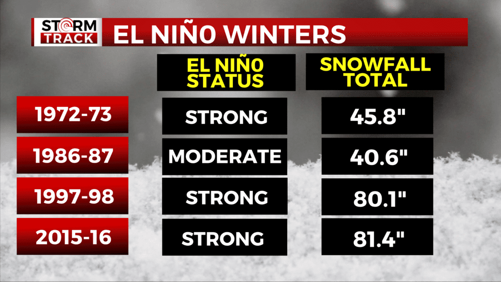
Right now, it looks like we are heading towards a strong El Niño. So far, the weather has been incredibly similar to the months leading up to the 1972-73 winter, a strong El Niño year.
This September, we had over ten inches of rain in one month. The last time we had that was in August of 1972 as La Niña transitioned to El Niño, as it is currently.
The 72-73 winter had a slow start, with only half an inch of accumulation by the end of October. December was the snowiest month that year with 20 inches. In addition to the August flood, 1972 was notable for the New Year’s Eve Blizzard.
All in all, the 72-73 winter only had 45.8″ of snow in Duluth. International Falls saw 30.4 inches, the third-lowest accumulation for the city on record.
Another noteworthy winter was 1986-87, which had a moderate El Niño. With only 40.6 inches of snow in Duluth, it was the fourth-lowest accumulation on record for the Zenith City.
The winter of 1997-98 had a strong El Niño with 80.1 inches of accumulation. That is still around ten inches of snow below-normal, but the temperatures are what made the 97-98 winter stand out.
With an average November to April temperature of 27 degrees, this winter became known as “Duluth’s Balmy Winter.” February was extraordinarily warm, averaging 28.4 degrees. That exceeded the normal by 16 degrees.
The most recent winter with a strong El Niño was in 2015-16 when we had 81.4 inches of snow.
A strong El Niño points to a mild winter with less snow and we’re looking to be some 20 to 30 inches below normal for the year.
November will start our winter with warmer than average temps and little snowfall. You could find yourself sitting in the deer stands in t-shirts. Ski hills will likely spend lots of money making their own snow.
December improves some as we’ll see close to two feet of snow. It doesn’t look like any major storms this December. As January rolls in lake ice will be poor which will be terrible snowmobile trails expect a shot of colder air when the polar vortex returns for a short time. We’re only looking at 13″ of snow and a small snowpack could create problems for the Beargrease. These conditions were similar in 2007 and 2013 — also El Niño years — and the sled dog race was canceled due to little snow. A risk we may see this winter, too.
However, if December is dry, we’ll get more snow in January, which could help the race. If we can run the trail, conditions will be sloppy, and temperatures will be warm, two things the sled dogs don’t like.
As February rolls in we still might not be looking at much snow, it might be enough for the Birkie in late February, but conditions could resemble the Beargrease.
Our biggest chance at a large storm will come in March as our pattern begins to change. In 2007 we had a huge blizzard that buried park point which was a weaker El Niño, but because it’s a strong El Niño not much is expected. Snow will continue into April with little accumulation as well.
In the end we think we end up with about 67″ in Duluth. As for the rest of Northland this map shows where you live.
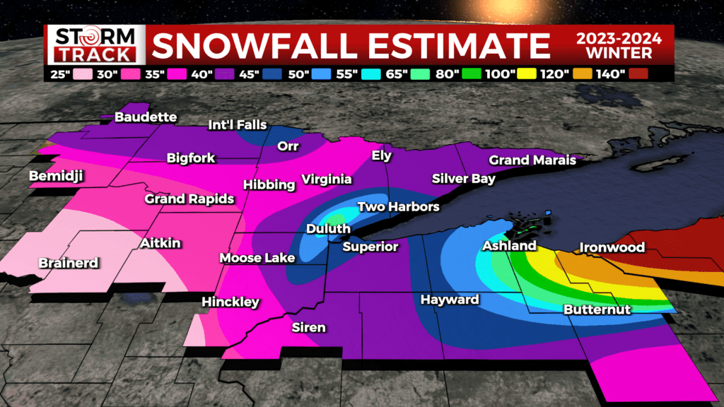
The snow belt along the south shore and U.P. of Michigan will likely be the hot spots for winter recreation. The big lake won’t see much ice this year just like the El Niño of 2016. The south shore will likely be lower than average but could still pick up over 120″.
A warmer winter also means we may see more freezing rain events in January, February and march. So where will all the snow be this year. Out east over states like Pennsylvania, New York, and Connecticut.