Justin Liles: Winter storm is coming
The big weather story is the large low set to cross the Rocky Mountains and move into the upper Midwest Tuesday. This is going to become a large snowstorm across the upper Midwest. Minnesota and Wisconsin could take the brunt of this. Blizzard like conditions along with heavy snow are the biggest threats as of now. The track of this will be key as to what we get. This may become larger and last through the end of next week, as it appears to slow down right over Minnesota.
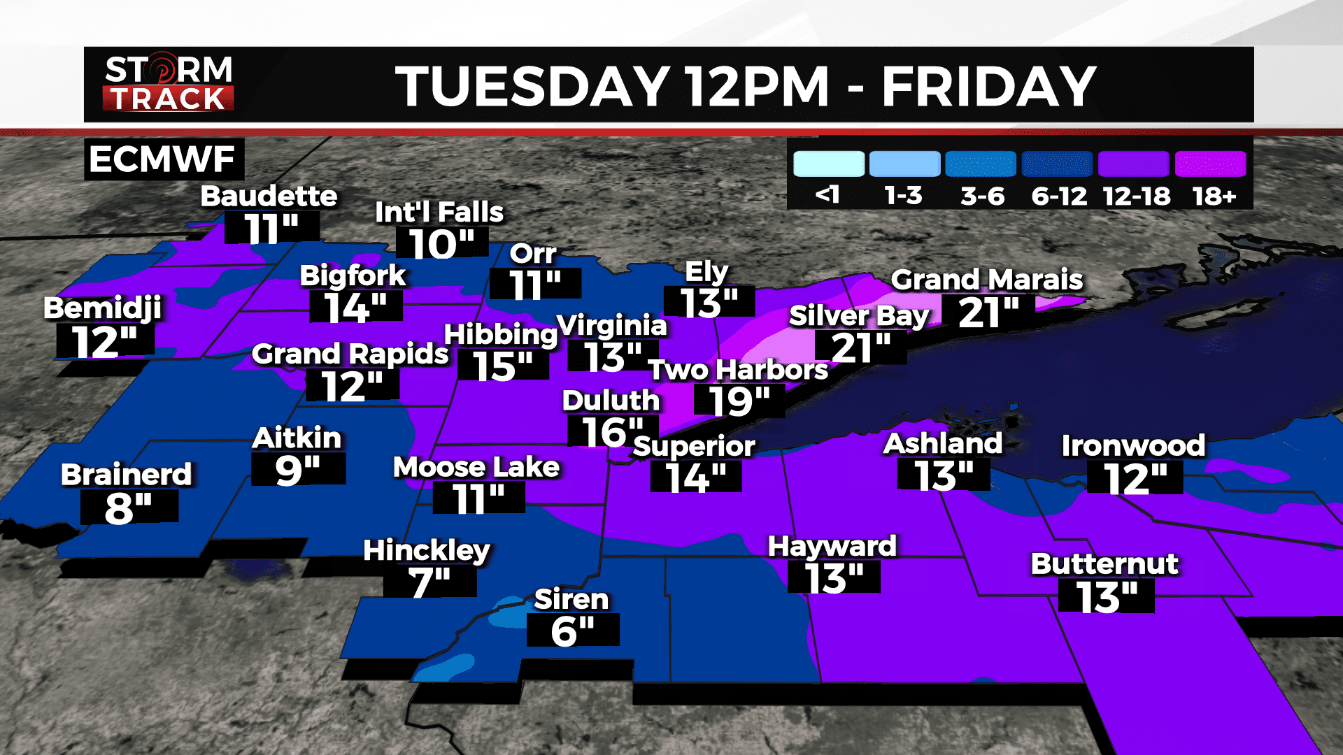
Snowfall totals are looking to be as much as a foot or more along the North Shore. It’s possible there could be some amounts on the north shore that could exceed a foot and a half. Winds will gusty off Lake Superior, creating blowing and drifting snow and poor visibilities. Wednesday and Thursday conditions look bad enough to keep an eye on future cancellations and closers. Please stay tuned and keep a close eye on our updated details.
TUESDAY
A 20 percent chance of snow after noon. Mostly cloudy, with a high near 34. Breezy, with an east wind 15 to 20 mph, with gusts as high as 30 mph.
TUESDAY NIGHT
Snow. Low around 29. Breezy, with an east wind around 20 mph, with gusts as high as 35 mph. New snow accumulation of 2 to 4 inches possible.
WEDNESDAY
Snow. Cloudy, with a high near 34. Breezy, with an east wind around 20 mph, with gusts as high as 35 mph.
WEDNESDAY NIGHT
Snow likely before midnight, then a chance of snow and freezing rain. Mostly cloudy, with a low around 28. Breezy, with an east wind 10 to 20 mph, with gusts as high as 30 mph.
THURSDAY
A chance of snow. Mostly cloudy, with a high near 32. Breezy, with a northeast wind 10 to 15 mph, with gusts as high as 20 mph.
THURSDAY NIGHT
A chance of snow. Mostly cloudy, with a low around 20. North wind around 10 mph, with gusts as high as 20 mph.
FRIDAY
A chance of snow. Mostly cloudy, with a high near 27. Blustery, with a northwest wind 10 to 15 mph, with gusts as high as 20 mph.