Sabrina Ullman: Calm start to week
[anvplayer video=”5167149″ station=”998130″]
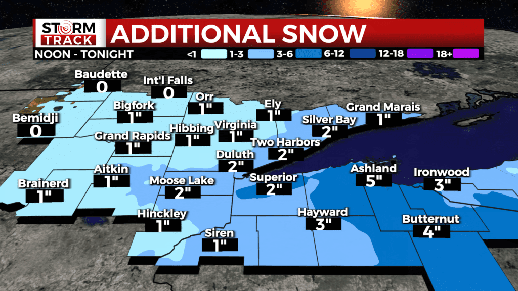
Snow will continue to impact the Northland until tonight. We will slowly but surely see this system exit the area, with the Iron Range and areas north seeing relief by 7 pm. For the most part, this snow will be done by Monday morning. Lingering lake-effect showers are likely for Bayfield, Ashland, and Iron Counties as well as the U.P. midday Monday.
RELATED STORY: Snow has canceled some church services. Here is a list of cancellations.
Additional snowfall accumulations for this afternoon into Monday will be mostly 1-3 inches, with areas close to Lake Superior having localized higher amounts. The Bayfield Peninsula and areas east will be closer to the 3-6 inch range for additional accumulation.
Road conditions are expected to be slick until late tonight, as gusty winds and light snow continues.
RELATED: Keep an eye on Road Reports
After this eventful weekend, we will have a quiet start to the week. Then, precipitation chances return with a rain/snow mix possible Wednesday.
For the most part, this snow will be done by Monday morning. Lingering lake-effect showers are likely for Bayfield, Ashland, and Iron Counties as well as the U.P. midday Monday.
The Storm Track Weather Team is currently tracking the potential for another Colorado Low to arrive later in the week, with more heavy, wet snow possible.
Tonight
A 30 percent chance of snow, mainly before midnight. Mostly cloudy, with a low around 9. Blustery, with a north wind 10 to 15 mph, with gusts as high as 25 mph.
Monday
Partly sunny, with a high near 26. North wind 5 to 10 mph.
Tuesday
Mostly sunny, with a high near 31. Northwest wind 5 to 10 mph becoming southeast in the morning. Winds could gust as high as 15 mph.
Wednesday
A slight chance of snow before noon, then a slight chance of rain and snow. Mostly cloudy, with a high near 39. Breezy, with a south wind around 15 mph, with gusts as high as 20 mph.
Thursday
A chance of snow. Mostly cloudy, with a high near 34. Breezy, with a northwest wind around 15 mph, with gusts as high as 25 mph.
Friday
A chance of snow. Partly sunny, with a high near 29. Blustery, with a northwest wind around 15 mph, with gusts as high as 25 mph.