Weatherz School: Clouds
There’s something inherently fascinating about just putting an eye to the sky and watching the clouds pass. Meteorologists have given names to the various cloud formations that we can be treated to.
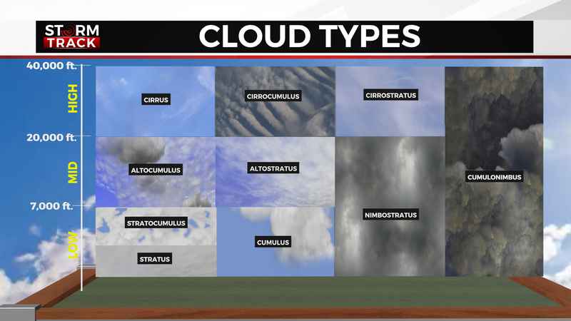
There are ten basic groups of cloud types that are categorized by how high up above the surface they are. A lot of cloud types come back to two root words:
- Cumulus: A round, fluffy cloud that is individually defined.
- Stratus: A uniform sheet of clouds lacking individual definition.
Both of these types of clouds are found in the lowest level, which is at an altitude less than 7,000 feet. Low clouds also include stratocumulus.
Mid-level clouds are between 7,000 and 20,000 feet in the air. Clouds at this level get the prefix “alto”; altocumulus and altostratus.
High clouds are above 20,000 feet. Clouds at this level are made of ice crystals, so they aren’t as large or dark as clouds at lower levels. Cirrus clouds are thin and wispy. The prefix “cirro” is used for all high clouds; cirrocumulus and cirrostratus.
Nimbostratus is a gray, uniform rain cloud that can be tall enough to extend into both low and mid-levels. Cumulonimbus is a thunderstorm cloud which can begin at low levels and reach into high levels. Cumulonimbus clouds can only rise until they hit the top of the troposphere, then the top flattens like an anvil.
There are 27 distinct classifications of clouds, but all of them fall into one of these ten basic groups.